Developing technology, as in many areas, enables the documentation, archiving and promotion of historical and cultural heritage. With GIS technology, it is possible to document and promote historical artifacts that are decreasing and being destroyed day by day, especially historical architectural artifacts that cannot be collected and placed in a museum, in a fast and widespread way. It was inevitable to create a database to associate the historical structures, features and inventory of Silvan and its immediate surroundings, one of the most important historical castle cities of Upper Mesopotamia. Even though it was late, such a study was carried out.
This study will constitute an important basis for many studies such as urbanism, tourism, history, archaeology and planning. With the profitable use of the historical and cultural assets information system of Silvan and its immediate surroundings, the loss of history and economic losses will be prevented. In addition, time and financial losses will be prevented in all kinds of planning, and later, in case of any change or in a different field of study, it will be possible to enter up-to-date information into the system.
With the information system of historical and cultural assets of Silvan and its surroundings:
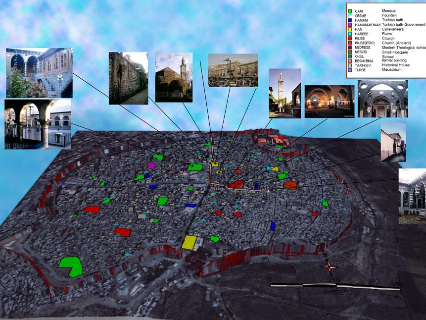
An inventory of a historical heritage that is gradually disappearing has been created, The location of the structures existing in photographs and archives has been determined.
Map bases that can be easily accessed and address queries have been created in tourism, guidance and planning activities.
Changes that will occur in the structures in the system over time can be updated as dates, a historical risk map can be created. In addition, all data can be associated with and analyzed socio-economic and demographic information belonging to the city of Silvan.
The production of new maps that can meet a wide variety of needs in line with different parameters and other operations of the city can be realized, this process will save time, money and labor.
Simulations related to various plans belonging to the space can be made using the digital bases and DEM data belonging to the system. Most importantly, the city can be successfully introduced to the whole world by integrating the system into the Web environment and with the help of an interactive map.
However, it should not be forgotten that in an area where technology is rapidly changing and developing, the work done should be updated within a certain plan and integrated into new tools.
Click here to go to the Silvan Atlas page.
Click here to go to the Silvan Atlas page.